You are here
Get Your Spatial Data On!
Posted by Lori Ayre on July 1, 2015
There are a lot of moving parts to coordinate in libraries today. Everything is changing very fast including everything related to the Internet, what we mean by “phones”, user expectations of customer service and discovery, DRM, funding levels, the increasingly long list of devices and technology that people use to create things, and the composition of our communities.
One of the things changing almost as fast as technology is our communities. Many communities are not just melting pots, they are roiling stews of people moving in and moving out with some communities getting older while others seem to maintain a permanently younger set. As people flee their countries of origin due to climate change, violence, or just to pursue opportunities, what were once static communities change and morph to accommodate the new arrivals with new cultures, practices, foods, and religions.
The good news is that there is data out there to help a library understand these migration patterns and to help the library understand more about the people living in the various neighborhoods within their service area. Using data in the library system combined with census data, and other spatial data, a library can learn who is and who is not using the library. They can identify areas of growth and plan for a new library and they can learn who lives in that growing area to ensure the collection and services reflect their needs.
Spatial data is any data that can be mapped to locations. Geographic information systems (GIS) and navigation systems like Nuvi, TomTom and Google Maps are commonly used examples of systems that rely on spatial data. The great thing about spatial data is that anything you can connect to a place becomes spatial data. There are thousands of data sets that do just that. Census data is one rich resource that provides demographic information like income, age, housing, education, race, spending habits, behaviors, and much more. And all these pieces of information can be associated with your own patrons. And, while you can’t look up the income, age, race or spending habits of an individual patron, you can see how many patrons you have in certain neighborhoods. And you can learn things about those neighborhoods. This neighborhood-level information is called “market segmentation” data. You can also overlay transportation information, planning information, health information, and any number of the thousands of data sets that exist over your service area to learn more.
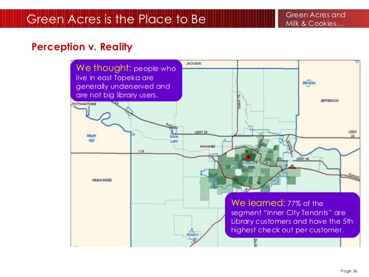
One company, Civic Technologies, has been doing this for libraries for over ten years. I must have seen one of the first presentations they ever gave at a library conference because it was that long ago. It blew my mind. The concept is so powerful and yet so simple. If you can map information to a location (e.g. latitude and longitude), you can learn things - a lot of things. And these things can help you make better decisions. In 2011, Gina Milsap wrote an excellent article for InfoToday describing how she used market segmentation data in the formulation of their strategic plan (https://www.tscpl.org/wp-content/uploads/2011/08/P.MLS-3368-R.pdf). I know she still relies on that data in her excellent work at Topeka and Shawnee County.
For many years, the folks at Civic Technologies were the only game in town. I think there was a kind of aversion to it on privacy protection grounds. Did it feel like snooping on our patrons? Or maybe it was just a technology that was too complicated for many of us to grasp, but now that we rely on our phones to tell us all about the world surrounding us, I think we’ve gotten more educated about GIS systems. We’ve also let go of some of our privacy concerns in favor of the convenience of finding the nearest Starbucks.
Making use of spatial data has been slowing catching on in libraries. Now Civic Technologies has competition from Orange Boy and Gale. Even Esri, the biggest player in all things GIS, markets to libraries now.
So, before you take another strategic step, consider investing in spatial data. Learn what there is know about the world around you –one latitudinal step at a time.